| Name | GEOSS Circular Trail |
| Full Address | Slovenija, Osrednje slovenska, Družinsko gledališče Kolenc, Vače 12, 1252 Vače |
| Koordinate | 46.1201555, 14.8359269 |
| Phone |
01 8976 680 / 041 895 852 |
| Spletna stran/vir | visit site |
| [email protected] |
The GEOSS Circular Trail is a marked excursion route in the wider GEOSS area near Vače. According to the official description, it is about 8 km long, with about 350 m of total elevation gain and loss, and usually takes around 2.5 to 3.5 hours to walk. It is designed as a self-guided hike that connects the main sights of the immediate Vače area while remaining manageable for a relaxed day trip. ([geoss.eu](https://geoss.eu/turizem/izletniske-tocke/krozna-pot-geoss/?utm_source=openai))
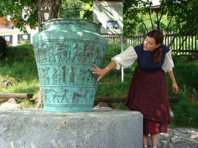
The trail starts and ends in the village of Slivna and passes Vače, Klenik with a larger copy of the Vače situla, the archaeological sites at Krona, Slemšek, Mačkovec and GEOSS itself. The official trail page says it is marked with “GEOSS circular trail” signs and individual waymarks, so it works well as an independent visit. ([geoss.eu](https://geoss.eu/turizem/izletniske-tocke/krozna-pot-geoss/?utm_source=openai))
This is a good choice if you want a walk that combines nature, local history and the symbolic centre of Slovenia. The route fits well as the main feature of a day around Vače or as part of a broader exploration of the Litija area. Since the official page does not list seasonal restrictions, it is wise to check conditions and any notices with the operator before you go. ([geoss.eu](https://geoss.eu/turizem/izletniske-tocke/krozna-pot-geoss/?utm_source=openai))
For guided information or route advice, the official GEOSS sources direct visitors to the GEOSS Association contact. Hiking shoes are recommended. The official description does not provide details about public toilets, food options, parking, dogs or stroller access; please check with the operator. For seasonal opening hours, possible closures or access changes, always verify the official site before departure. ([geoss.eu](https://geoss.eu/?utm_source=openai))
We verify details against official sources and structure them as a practical guide. Always reconfirm changing information with the operator.
Help us keep this guide accurate. We verify every report before updating the page.